Mes: mayo 2013

Yellowstone National Park in Wyoming

Yellowstone National Park in Wyoming

Yellowstone, the oldest national park in the world (1872), is a large volcanic caldera that concentrates endless geothermal phenomena, two-thirds of the geysers in the world and numerous hot springs. In addition, the tour of the five regions discovers that is home to black and 

The Sahara Desert

The Sahara Desert

The Sahara Desert is the largest hot desert in the world. Exceeds 9.065 million km2, which means it has almost the same size as China. It is located in northern Africa and has more than 2.5 million years. Its name derives from the Arabic translation 

The Alhambra in Granada

The Alhambra in Granada

The Alhambra in Granada

The Alhambra in Granada. Declared a World Heritage Site, is undoubtedly the most emblematic monument of the city and one of the most visited in Spain. It consists of a defensive side, the Alcazaba, the Nasrid Palaces and the Generalife Gardens.

The Alhambra emerged on the hill called La Sabika, also known as San Pedro or the Red Hill, by the color of their land. In this hill there was a very old fortress, perhaps the s. IX, and on it the first king of the Nasrid dynasty, called Alhamar, began construction. The year was 1239.

We take a walk through it, discovering its palaces, fountains, gardens, towers and gates. The Alhambra was a city for the Moorish king, his government and his knights. Also lived many people dedicated to work on it.

Hill is the highest elevation around Granada. It is a citadel because within its walls was a real city, with all means necessary. However it should be considered as a city for royalty inserted, yet separate, in the city or medina of Granada. Let’s say it was like a private city.

The Alhambra in Granada 2

As we see is elongated and rather irregular and must adapt to uneven Sabika mount. Its length is 2,428 feet and its width varies between 590 feet and 132 feet.

It is surrounded by a wall that is double in some areas with 27 towers that had different functions, most served for defense but others served as homes, even some of them were like palaces. You could access it by four gates: Gate of Arms-in-Alcazaba, the suburb-in-Peak Tower, Seven Floors-south-and-also Justice or south Esplanade.

His name is not very clear. Some believe it is because it was built at night under the glare of the torches. Others say it’s the name of your builder female Alhamar and therefore be called The Red Alhamar wife.

The Alhambra in Granada 3

This monument is the most important and beautiful of those built in the world Islam. Welcoming more than 2,200,000 visitors a year. Watching her from the Mirador of San Nicolas, Bill Clinton said he attended «the most beautiful sunset in the world». Its walled town occupies 104,697 meters square, in addition to so many of the Generalife. The first references to al-Qal’a Alhamra («The Red Fortress») are the ninth century, but it is from 1238 when the Nasrid Sultans there begin to build their buildings, in principle defensive. The main palaces and rooms were built at various times between the early fourteenth century and the second half of that century. Its walls are traveled by thousands of verses inscribed on them: only in the Comares Palace are documented more than 3,000 inscriptions in Arabic. It was declared a National Historic Landmark in 1870.

Preikestolen Cliff in Norway

Preikestolen Cliff in Norway

Preikestolen is a lift which has more than 1980 feet high and is located at Lyse fjord located in Ryfylke, which in turn is located in the region of Rogaland in western Norway. The best way to reach this wonder of northern Europe, one of 

Potala Palace in Tibet

Potala Palace in Tibet

The Potala Palace is located in the Red Mountain in the center of Lhasa City. «Potala» is the phonetic adaptation of «Putuo» which in Sanskrit means «island inhabited the Buddha of Mercy». This imposing building was begun in the 7th century, ie at the time 

Tasmania Island in Australia

Tasmania Island in Australia

Tasmania Island in Australia

The island of Tasmania is completely different from Australia to find on the mainland. You will not find arid deserts, but rugged mountains, rolling green hills and raging rivers furrowing the landscape of the island. Tasmania is one of the most picturesque islands in the world, with over 20% of its total area a World Heritage Site and another 10% classified national park or reserve.

But Tasmania is more than fascinating landscapes is that Tasmania was one of the first areas of Australia where Europeans settled, in addition to a past rich in history and criminal prisoners.

Tasmania is the smallest state in Australia, both in size (remember that Canberra is not a state but a Territory) and the number of inhabitants. However, is one of the most visited regions by tourists by their nature, much of it still wild, and for its heritage.

If you like good food, you’ve come to the right place. Many food manufacturers in the region take advantage of the clean environment of Tasmania to produce high quality products. For example, Tasmanian beer is made with one of the cleanest waters in the world.

The climate in Tasmania is nice and the island has four distinct seasons (very similar to the conditions of central Europe but without the harsh winters), which makes the island an ideal place for tourism throughout the year. The warmest months are from December to March, being reached average temperatures of 23 º and the coldest from May to August, with average temperatures that do not exceed 11 º. Rainfall varies throughout the island. Hobart is the second driest city in Australia after Adelaide, while the west of Tasmania is one of the wetter areas of the country.

Tasmania Island in Australia 2

The great state of Tasmania, along with little artificial light that is reflected in the Tasmanian night sky makes it an unparalleled place to contemplate the wonderful Aurora Australis.

Being a relatively small island Tasmania, distances between destinations are as well, and rental car transportation is a perfect base for exploring the island. The two main roads of the island, one lane in each direction, are generally in good condition and hardly any traffic. The roads, especially those on the West Coast can be quite winding and steep and, during the winter months, the main roads are usually covered with ice and sometimes snow.

The aborigines already wore inhabiting Tasmania thousands of years. These aborigines had frequent contact with the mainland before the island was separated completely from the rest of the land mass. After the island was isolated from the rest of the country, these aborigines developed different customs from other aboriginal tribes. Older Aboriginal people in Tasmania are in the northern part of the state.
The first sighting of Tasmania by the Europeans came in 1642, when the Dutchman Abel Janszoon Tasman reached the island. It was originally called Van Diemen’s Land, in honor of the Governor of the Dutch East Indies.

During the 150 years since, many Europeans came to their shores to explore the new land, among these explorers was Captain Cook and many French, and none of them realized that they were visiting an island rather than part of the continent. The island became a British settlement and a penal colony in 1803. Until 1825, Van Diemen’s Land belonged to the state of New South Wales. In 1853 the last convicts arrived in Tasmania in 1856 and established a local government and adopted the name of Tasmania.

The best-known as Port Arthur was criminal, but this was not the only nor the first. Other areas in which the convicts were housed Sarah Island, where living conditions were extremely harsh and where prisoners often made suicide pacts, one of them killing his partner in order to be taken to Hobart where he faced to the gallows, or Maria Island.

Around 1870 gold was discovered in Tasmania and seekers of the precious metal got to work exploring most of the island’s terrain. This raised much controversy due to over resource exploitation natural of Tasmania. This debate, which was really bloody in the 1960s and 1970s still continues today.

The Big Ben in London

The Big Ben in London

Known as Big Ben, the famous clock of the Houses of Parliament has become one of the most famous images of London, and one of the main symbols of the city. The tower, built in 1858 by the new Palace of Westminster, is a peculiar 

The Great Barrier Reef Coral in Australia

The Great Barrier Reef Coral in Australia

This is one of the wonders of the world. The Great Barrier Reef, which stretches from Cooktown in the north to Bundaburg in the south, is a mass of coral reefs and islands that make up the largest marine park in the world. Unfolding from 

The Terracotta Warriors in China

The Terracotta Warriors in China

The Terracotta Warriors

The Terracotta Warriors («figures of soldiers and horses»), within the Mausoleum of Qin Shi Huang, also known as Mausoleum of the First Qin Emperor (秦始皇 陵; pinyin: líng Qinshihuang) was discovered in March 1974 during a works for the supply of irrigation water near Xi’an, Shaanxi Province, PRC. Since 1987 is considered World Heritage by UNESCO.

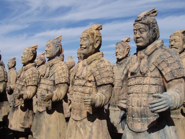
The army consists of over 7,000 figures of warriors and horses in real size, which were buried with the self-proclaimed first emperor of China, Qin Dynasty, (Qin Shi Huang) in 210-209 a. C.

Burying these statues was believed that the Emperor would still have troops under his command. The Terracotta Army was buried in battle formation on three pits, one mile east of the Emperor’s tomb, located 33 km east of Xi’an. The three pits are between 4 and 8 feet deep. They have been excavated and a museum has been built in the ruins, called Terracotta Army Museum of the First Qin Emperor.

The first pit was discovered in 1974 by chance by some peasants who were looking for water to combat drought. In that area had already found some remains of those who had been given too much importance to the news of the discovery of the new pit reached the ears of an archaeologist began excavating.

The pit has an area of ​​200 meters by 60 and contains more than 6,000 warriors, some of them still to be unearthed. The figures are life-size: measured 1.80 m. high and are equipped with armor also made terracotta. The grave was opened in 1979.
The Terracotta Warriors 2

Each of these figures has different features and characteristics: mustaches, hair, young, old, different ethnic traits … Heads and hands are molded separately and then added to the bodies. Uniforms also reflect the military ranks to which they belong. Each soldier carried a weapon: bows, spears, swords … After the fall of the Qin Dynasty, peasants looted the tomb and stole the weapons. Originally, the images are vivid and bright colors, color is lost after five hours of exposure to oxygen, which contributes to its oxidation. It is for this reason that we are studying the technique to keep these colors and until completion of their study are deferred excavations of other warriors.

The second pit to open the public contains 69 figures and is known as «the pit of the generals». It is believed that represented the staff of the army. In the pit are also visible figures of four horses. The last pit contains about 1,000 soldiers, many of them without restoring.

In 1980 he discovered two painted bronze chariots. Each of these cars is made up of more than 3,000 pieces. The four horses of each carriage are guided by an imperial driver. According to some studies, the first of these cars would help pave the way for the emperor’s entourage while the second would be the car in which the monarch sleep. The cars are not actual size (about half) and were inlaid with silver and gold.

The Terracotta Warriors 3

The mausoleum is located on Mount Li, about 30 kilometers east of the city of Xian, in the district of Linton, in Shaanxi Province, northwest China.

The mausoleum remained forgotten and buried 2,000 years. The emperor spent nearly 38 years to build the mausoleum. Which has 2.13 square kilometers and together with other 181 tombs spread in the area, covering a total area of ​​60 square kilometers and included the participation of more than 700,000 workers. It was built according to the urban plan of the city of Xian yang, the ancient capital of the Qin Dynasty, also divided into two parts: inside and outside with a truncated pyramid with a base of 350 meters and a height of 76 meters.
The burial chamber tomb of the Emperor and have not been opened and are in the center of the underground palace of the mausoleum.

To get easy to Xian, capital of Shaanxi Province in northwest China, it’s best to take the high speed train TGV of state-owned China Rail from Beijing. Between the two cities there are 1,200 km, but the train moves through them in less than six hours.

Tourists enjoy an unforgettable show, which brings to mind the time when the Imperial Guard marched with pomp. In an area of ​​16,300 square meters, divided into three sections or «wells» archaeological replicas were restored 7000 soldiers, officers and generals, 130 chariots with 520 military horses were rescued weapons and bronze sculptures, including a set of horses. The imperial funeral procession included other figures in terracotta, unearthed in recent years: acrobats, musicians, servants and bodyguards. The different «wells» regrouped since 2010 in the Mausoleum and Park of Emperor Qin Shi Huang.

The Great Temple of Abu Simbel in Egypt

The Great Temple of Abu Simbel in Egypt

Abu Simbel (Arabic: أبو سنبل or أبو سمبل) is an archaeological site comprising two massive rock temples in southern Egypt on the western bank of Lake Nasser about 290 km southwest of Aswan, near its original location . The temples are part of the Open