Etiqueta: portada

Pamukkale, The Cotton Castle in Turkey

Pamukkale, The Cotton Castle in Turkey

Pamukkale is a strange geological formation found in the Aegean region in Turkey. At first glance are a number of full terraced water with high calcium content of incredible beauty: «The tectonic movements that took place in the depression of the failure of the basin 

The sentinels of the Arctic in Finland

The sentinels of the Arctic in Finland

One of the most beautiful places in the world, whose landscapes may serve as a reason for postcards, is the Finnish region called Lapland. An extraordinary phenomenon occurs during the winter, the trees are covered with ice and snow in such way that adopt shapes, 

The ruins of Calakmul in Campeche, Mexico

The ruins of Calakmul in Campeche, Mexico

POSTER

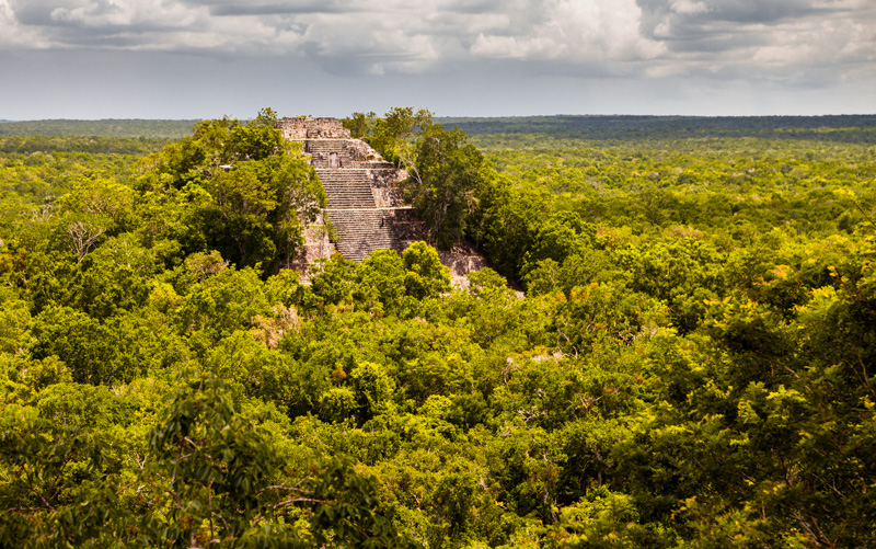
Calakmul is one of the largest and oldest discovered Mayan cities. Calakmul is located in the region of Campeche, just 30 km from the border with Guatemala, this city was inhabited during the years 500 BC and 1000 AD, and was «rediscovered» in 1931 by Cyrus Longworth Lundell. In 2002, the Ancient Maya City of Calakmul became part of the World Heritage of UNESCO.

Calakmul meaning City of the two adjacent pyramids, has one of the largest pyramids of the Maya Classic period of 45 meters. This great Mayan city Tikal rivaled the fact that the most important city maya, and political triangle formed Palenque Maya.

The Mayan city of Calakmul is within the Biosphere Reserve of the same name, more than 720,000 ha, a place with a spectacular biodiversity. There are about 1500 species of plants, 10% of them endemic, 236 species of birds, of which 75% are residents, 86 different species of mammals, and 5 of the 6 species of felines known Mexico we can find them here such as the yaguarundi or lion, ocelot or margay, ocelot, puma and jaguar impressive, Maya symbol par excellence. With these numbers, just set ourselves a little in the trees around the road during the tour to find the most curious animals, especially insects.

Escaleras

The intense humidity of the jungle and the strong tropical heat make this an ideal place for animal life and to the ancient Mayan civilization as Calakmul was the tank rainwater from the Yucatan peninsula, having many gaps in the area. This also makes the place smell like a warehouse, although we are outdoors, or rather, in a lush forest.

Walk a few hundred meters in this environment is tired if we are not used, but little effort is richly rewarded as the first ruins that are visited, a small residential area where the houses look and intuit places as familiar as the bed or the living room. Calakmul only been studying since 1993, so that archaeologists are still working and making constant discoveries in the interior of the temples, we can not visit, but if you see from the photographs to show us the guide to the colorful murals and tombs that recall the eastern civilizations.

Estructura I de Calakmul

After several residential areas, each with its peculiarities, cross the wall to get to the center of the great Acropolis and one of the biggest attractions of Calakmul, Structure I, a huge pyramid that we can climb, step by step, to marvel the views from the top. Miles and miles of jungle green plain that is lost to infinity, where only a small mountains that may mark the border with Guatemala or Chiapas be spotted, such is the enormity of the landscape, and another pyramid that stands on the orchard, Structure II. Interestingly there is little silence, hearing both wind rocking the treetops as disparate fauna that lives here.

Climb to the top of a Mayan pyramid and feel that perhaps you and your group you may be the only people in the area that the eye is an indescribable feeling, and that in a few places you can experience.

Known Structure I, touches repeat experience with the immense structure II, with its 55 meters high it is the second tallest pyramid in Mexico after Tonina in Chiapas. Nothing approaching your base you realize its importance as five trails welcome you, telling you a little story virulent Calakmul and its rulers. Always eternal wars with the relatively nearby Tikal, the other great Maya city of the era, as well as other small towns, in 562 the period of splendor of Calakmul, thanks to overcome many of these wars began. But the good times did not last long, beginning its decline on the 675, after a great loss to Tikal that led to the disappearance of the kingdom of the snake or Kan, who had led the city to its glory days.

Estelas de la Estructura II

A drought in 40 years did not help the revival of the city, who lived a long agony until completely abandoned about the year 900, after more than 2000 years giving shelter to 60,000 Mayans. All this is known by the approximately 120 stelae found in Calakmul, large stones that tell parts of the story and the kings showed their power, being the largest collection of stelae found.

Up to 55 meters high of Structure II is a bit more complicated than the previous pyramid, rather than the height of the great separation of the steps, and because this building had quarters in their intermediate levels, which makes us stairs to switch repeatedly until you reach the top, where there are several ceremonial sites, and of course, splendid views of the rainforest. From here it is easy to understand why top Cyrus Longworth Lundell gave the name of Calakmul to this city formerly called Ostetun, since in Mayan means «two adjacent mounds» in clear reference to these pyramids that never stopped growing while the city was alive reflecting the view that the Maya had the world. Stelae were to represent trees and pyramids were mountains.

Estelas delante de la pirámide

Two hours just give to appreciate the magnitude of Calakmul, which holds great mysteries such as how they managed the Maya to feed so many people on land that is not good for farming corn, their main food. It is suspected that a local nut, known as Ox or plant Ramon (Brosimum Alicastrum) was what they ate to survive, due to its high amount of protein, but still nothing is clear.

What is clear is that these are the most isolated and wild ruins around Mexico, where a true adventurers can feel completely alone touring this great city as we imagine wars, parties, romance, rituals and everyday that took place in this small clearing in the jungle inhabited by the Mayas.

To reach Calakmul, Campeche we recommend going up, which is 300 km from Calakmul. These three or four hours of driving from Campeche to Calakmul is where most Mayan structures in the world are concentrated. From Campeche take Highway 180 towards Champotón-Cd. del Carmen. When you see the sign for Escárcega and Highway 186 Take it and go on towards Calakmul Biosphere Reserve area. Although the roads are paved, are very narrow and winding, and may be that you find iguanas, snakes and other animals in the middle of the road and be a wait to depart. The road ends at a small parking that is the «official» entry Calakmul, from here you have to walk 2 or 3 miles to the entrance of the city. The funny thing is that you’ll be climbing mountains are not mountains in its exact term, but Mayan pyramids or buildings that have yet to be unearthed.

Estructura VII desde la estructura II

Some guidelines suggest reach Calakmul night and start visiting the Mayan city early in the morning (in Calakmul open at 8 am), there are some hotels near the city. You can also find hotels in Chicana, a half hour drive from Calakmul.


Hours: Monday to Sunday from 8:00 to 17:00

Payments at the entrance (to choose depending on the vehicle)

Small fee for access to vehicle traffic 20km: 56 pesos ($ 3.75)

Access fee for large vehicle traffic 20km: 100 pesos ($ 5.70)

Fee per person per transit 20km: 28 pesos ($ 1.60)

Payments museum

Roundtrip transfer vehicle especially the archaeological museum area: 70 pesos ($ 4)

CONAP law for access to the reserve (required): 50 pesos ($ 2.85)

INAH right to access to the archaeological site (mandatory): 47 pesos ($ 2.70)

Skyscrapers more ancient of the world in Shibam, Yemen

Skyscrapers more ancient of the world in Shibam, Yemen

Shibam is the name of a beautiful location in Yemen, whose Antigua and Walls city were declared a World Heritage Site in 1982. It is a spectacular mini-isolated city in the desert, whose characteristic «mini-skyscrapers» of between 5 and 11 live about 7,000 homes. The 

The Acropolis of Athens in Greece

The Acropolis of Athens in Greece

The Acropolis is the most important archaeological site of the city, the watchword of Athens in particular, and Greece in general. The meaning of the word ‘Akropoli’ city high, do honor to his name, as the site on which it stands is 156 meters above 

Palouse Falls in Washington, United States

Palouse Falls in Washington, United States

Palouse falls

Palouse falls are a huge leap that gives the river of the same name. This splendid precipitation is 4 miles (6.4 km) stream above the confluence with the Snake River, Southeast of Washington, United States.

They were created during the flooding of an ancient glacial lake called Missoula. The Palouse River passes through a large and productive region that was territory of the Palus Indians, also called Palouse or Wawyukma.

[smartads]

The waterfall has a height of 200 feet (61 meters) and detaches from a higher fall of 20 feet (6.1 meters). In fact, they make up a succession of falls, being the smallest of 180 feet (55 meters). But it is not only the waterfall which takes visitors but that whole environment looks in that it engages, which is an amazing canon, it makes this tour a unique adventure.

Palouse falls 2

The part of the canyon where lower large water curtain reaches 115 meters above sea level and, in addition, is a clear sign of the Columbia River basalt group. The landscape was born at the time of the Pleistocene, when fluids Missoula swept the area giving these so characteristic forms.

Throughout the territory in which these natural wonders are part belongs to the Palouse falls State Park, which helps to protect all your valuable natural heritage. This also allows access to the falls is easier and more controlled, and to have been responsible for go counting on posters all the geological history of the place including the aborigines who lived here and the Mullan road that crossed the area.

This waterfall and Canyon are really a beauty that keeps United States for travelers. Near the Capitol, it might be hard to imagine a natural attraction like this, but luckily, the advancement of man even preserves these gems so that we can continue to amaze us with them.

Rafa Ortiz - Action

In 2009, Tyler Bradt 22-year-old, broke the record of fall kayaking world to descend the 55 meters of the Palouse falls. Tyler had a clean fall and suffered a slight injury in his wrist.

Dead Vlei, incredible cemetery ghost trees in Namibia

Dead Vlei, incredible cemetery ghost trees in Namibia

Dead Vlei, also known as «the frying pan of clay», is located in the reserve of the Namib-Naukluft Park, in the Namib desert, considered the world’s longest desert, because it already existed during the tertiary Era, the period in which the dinosaurs became extinct. Namib, 

Cenote Angelita, a river underwater in Mexico

Cenote Angelita, a river underwater in Mexico

Located in the Yucatan Peninsula, Mexico, is a secret underground river called Cenote Angelita, which can be located after 10 to 15 minutes drive by car to the south of Tulum. It is relatively difficult to access as there is to walk at least five 

Christ the Redeemer in Rio de Janeiro, Brazil

Christ the Redeemer in Rio de Janeiro, Brazil

angry-lion-rio-hd-www-pq-eu-funny-pics-253075

On July 7, 2007 Christ the Redeemer in Rio de Janeiro was named as a winner in the list of the Seven Wonders of the Modern World by the New Open World Corporation through an open online vote in which participated, according to the organization, 100 million people.

In Brazil a campaign to vote for the Christ called «Vote no Cristo» (Vote for the Christ in Portuguese) and an estimated 10 million Brazilians participated in the voting organized.

The Christ the Redeemer statue Corcovado or Christ is a statue of 38 meters that represents the figure of Jesus of Nazareth with open arms, looking towards the city of Rio de Janeiro and the sea.

Christ the Redeemer is located at the top of Corcovado Mountain in the Tijuca National Park, 709 meters above sea level, and has a total height of 30 meters.

Christ_on_Corcovado_mountain

The idea of ​​building a religious monument in the city was first suggested in 1859 by Father Pedro Maria Boss and Princess Elizabeth. In 1921 the idea was taken up and the April 4, 1922 the cornerstone was laid. Four years later the works began.

The first sketches made ​​by the artist Carlos Oswald imagined Christ carrying the cross, with a terrestrial globe in the hands on a pedestal symbolizing the world. Finally we chose the current design, also Carlos Oswald.

The project was developed by Brazilian architect Heitor da Silva Costa and took nearly five years to be completed. The executor of the sculpture was the French sculptor Paul Landowski.

To the coating various work materials were studied to finally select the «stone-soap». While it is a weak material, which can even be scratched with fingernails is extremely resistant to the passage of time, it does not deform, or crack with changes in temperature.

The construction of more than 1,000 tons, combines engineering, architecture and sculpture and no one died during the titanic construction, something really unusual for the time.

The lighting system was replaced twice: in 1932 and 2000 In 1980, during the visit of Pope John Paul II was restored as in 1990 In 2003, an escalator system was inaugurated, thus facilitating access to the platform of the statue. Were also installed three panoramic elevators, each with a capacity of 13 people, or a ton of weight.

christ_the_redeemer

How to get to Christ the Redeemer?

Train:
In Cosme Velho Station, in the district of the same name, you can board the train, leaving every half hour, taking twenty minutes to go through the forest and reach the top.

Car:
From the South Zone – the neighborhoods:
• Cosme Velho – by Ladeira Guararapes or Ladeira do Ascura
• Santa Teresa – along Rua Almirante Alexandrino

From North Zone – the neighborhood:
• Alto da Boa Vista – by the Estrada das Paineiras

Cars must be parked in the Paineiras. From there, the rest of the journey must be made ​​by train or on foot (about 2 km. Upload). The buses are parked at the toll barrier.

Telephone: (55-21) 2558-1329 (Corcovado Railroad), (55-21) 2492-2252 (Tijuca National Park)

The Perito Moreno Glacier in Argentina

The Perito Moreno Glacier in Argentina

The most famous and imposing glaciers of the National Park is the Perito Moreno Glacier, located in the south end, opposite the Magallanes Peninsula, 78 Km. El Calafate. For the spectacular view it offers, the Perito Moreno glacier is considered the Eighth Wonder of the