El Tajin archaeological zone in Mexico

El Tajin was the ancient capital of the Totonac culture. According to experts, was a contemporary of other great Mesoamerican cities such as Teotihuacan (in central Mexico), Monte Albán (Oaxaca) and Palenque and Yaxchilan, in the Mundo Maya.
Today we know that its period of greatest splendor caught between the sixth and seventh centuries, when its inhabitants, true masters of the art of architecture, erected their main buildings, among which are: The Pyramid of the Niches, Building 5, and the numerous and beautiful ball games scattered throughout the length and breadth of the ceremonial center.
El Tajin is the most important pre-Columbian Mesoamerican city of the north coast of Veracruz. His influence includes the basins of the Rivers and Dogfish Tecolutla from the Sierra Norte de Puebla, where its influence is apparent in the archaeological zone of Yohualichan, until the coastal plain of the Gulf of Mexico.

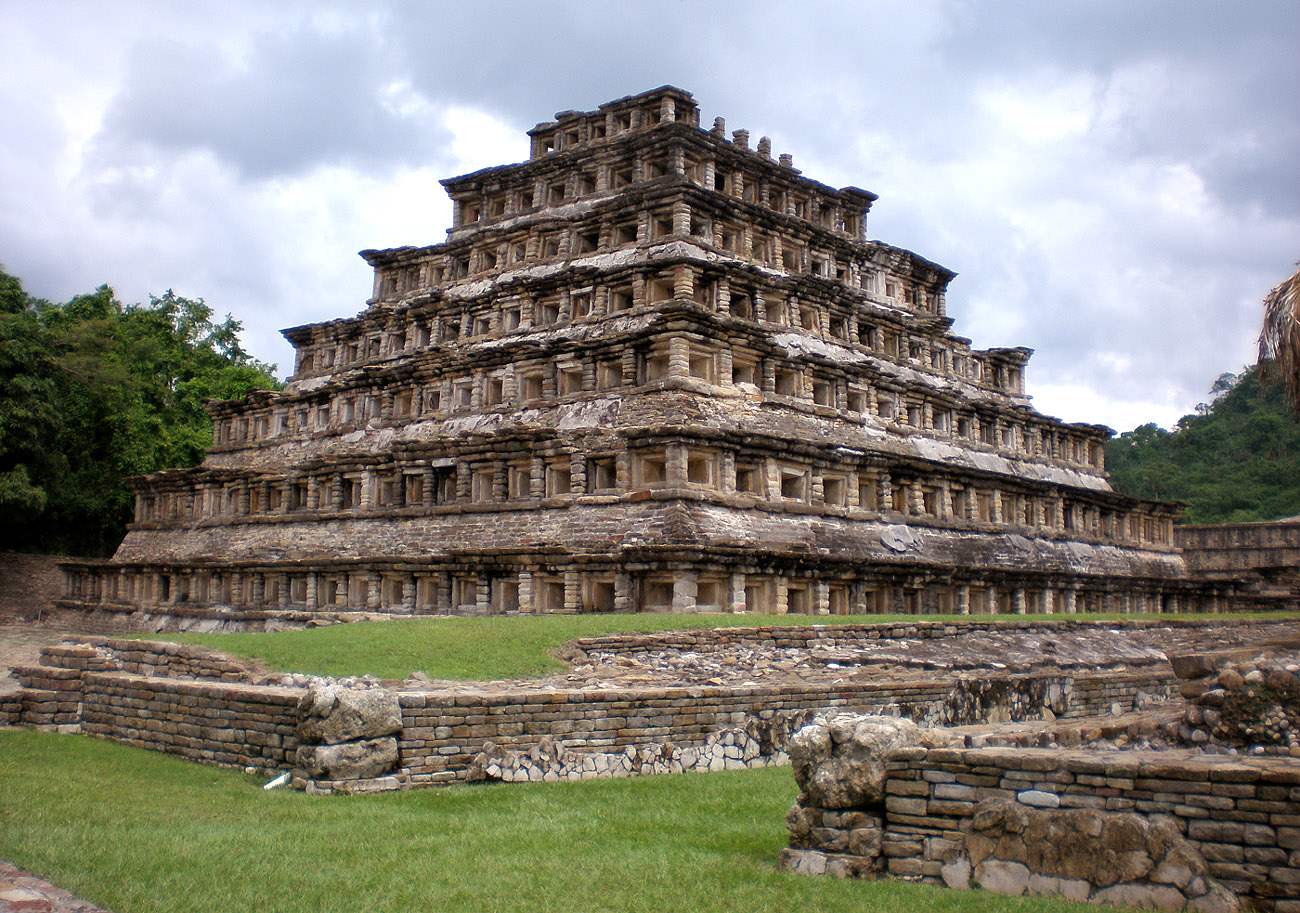
From the planning point of view Tajin large open spaces enclosed by temples and slopes were privileged. Besides niches decorations, reliefs and wall paintings. One of the most interesting buildings is called the Pyramid of the Niches, named because the boards that make up their facades were decorated with niches for a total of 365, why has received attention from scholars in Calendar and Mesoamerican worldview.
El Tajin is the city with the highest number of ball games: 17, which has been interpreted as a necessity to cultural diversity, according to the time, was living in the city. Chronology: A.D. 300-1200 Location chronological principal: Epi, 600-900 AD.

The construction pattern of El Tajin buildings consists of square or rectangular base with one or more superposed. In addition, the basic design of temples and shrines no different from Mesoamerican pattern. These are generally truncated pyramidal structures with a ladder and alfaradas forward. El Tajin was built in the bottom of the alluvial fans of the Sierra Papanteca. Two ravines determined expansion north – south central wall of prehistoric settlement. The ceremonial center buildings are located in a staggered succession of artificial platforms and concourses surrounded by hills. The various altimetry and subsequent leveling of land served by retaining walls while architectural barriers to structure the urban universe.
[smartads]
The natural decline was exploited in the urban structure, the core could be divided into five parts: Plaza del Arroyo Group, the Central Zone, the Gran Xicalcoliuhqui, Tajín Chico and the Column Set. The monumental core or center of the old city of El Tajin is spread over an area of approximately 1.5 square kilometers and consists of 168 buildings constructed with perishable materials, mostly, were intended to temples, altars, ball games and palaces.

Most of the ruins are aligned on an axis that runs north to south. The most representative structure is the Pyramid of the Niches, 25 meters high, with 365 niches each painted with red background and blue frame color. Represent the days of the solar calendar. The structure is rare and originally had a temple on top.
Two stunning tennis ball game, north and south, whose walls are decorated with inscriptions showing the rituals of the game. The study of these drawings has allowed to know that at least one player was sacrificed at the end of the game. The winners were killing one member of the losing team with an obsidian knife, who considered an honorable way to die. In Mesoamerica the ball game had a ritual character.
Other buildings of interest are the four pyramids around dela Plaza del Arroyo, the statue of the god of Tajin, representing the god of thunder and area «Tajin», believed to be a residential area for the rulers and the Great Xicalcoliuhqui, construction is believed related to Quetzalcoatl.

Do not miss the opportunity to visit this wonder if going to the Gulf of Mexico!
Upon entering the site you can enjoy the spectacle of the Papantla Flyers.
70 km north of the port of Veracruz is located, or, 12 km southeast of Poza Rica.
The nearest airports are in Poza Rica and Veracruz.
By car Highway 180 north of Veracruz, Papantla address.
From Mexico City, take Highway 132 to Tuxpan; reaching Poza Rica, turn south to Papantla.
On the bus trip to Veracruz Papantla.
There is a spectacular religious ceremony performed by the Totonac asking soil fertility; this tradition has endured for over 700 years.
Involves four Flyers and Caporal, who plays music and dances throughout the ceremony. The first to climb to the top of the post is the Caporal, who is placed in a small wooden platform where he dances and plays music with a flute and a drum to summon spirits. El Caporal is not subject to any string and there is not a network as a safety measure in case of a fall. This is an awesome moment!
Then climb the four dancers who launch themselves at the same time, each tied a rope to his feet and turning as they go down. It is important to note that the wooden structure where the dancers descend not tied to the post. To maintain balance, flying should have a similar weight.
His suits are bright colors representing the four elements of nature: fire, water, air and earth. Blue for sky, yellow sun, red fire and green trees. White represents purity.